Free Photos (Public Domain Photos),stock Photos, Clipart, images, and Vectors

A large Public Domain photo repository with high resolution free photos and vectors. All copyright free stock photos and royalty free photos, and CC0 Photos. 27000 free and public domain photos, images, clipart, pics and vectors and counting. To view/download a photo in high resolution, please click on the image.

Sponsored Images via Shutterstock: Coupon Code: GFP15 for 15% off
Hawkeye Point in Iowa, with bark, silo and informational displays to mark the state’s highest point
Looking back to Hawkeye Point with falls coming out of Goat Lake.
Iowa, IA, political map, with the capital Des Moines and most important cities, rivers and lakes. State in the Midwestern region of the United States of America, nicknamed The Hawkeye State. Vector.
Iowa, IA, gray political map, with the capital Des Moines and most important cities. State in the Midwestern region of the United States of America, nicknamed The Hawkeye State. Illustration. Vector.
USA map with magnified Iowa State. Iowa flag and map. Rasterized Copy.
USA map with magnified Iowa State. Iowa flag and map.

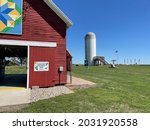
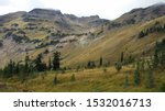
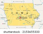
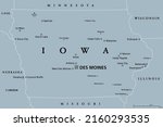
One of the easiest state high points to get to, hawkeye point stands at 1670 feet above see level and is located is north-western Iowa. It is located a small distance away from an old silo. Exit off the main road and drive about 200 yards to reach Hawkeye point.