Free Photos > Public Domain Images > Satellite View of Philadelphia, Pennsylvania (8568/19062)

To view or save this photo in High resolution, just click the photo to see the full image(the full image is much higher quality and not pixelated).

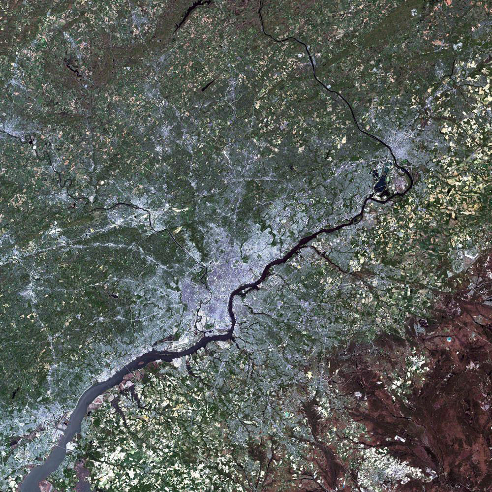
Satellite View of Philadelphia, Pennsylvania. Photo by NASA.

All free photos on this site are public domain. Please consider giving a credit hyperlink to https://www.goodfreephotos.com if you use the photos on this site using the attribution code in the below box. It is not required but it'd be much appreciated.

This photo is under the CC0 / Public Domain License.

Sponsored Images via Shutterstock:
Pennsylvania satellite image at night 3d perspective
Philadelphia (USA, Pennsylvania) night view with street lights. Aerial shot from space. top view heading south, . 3d render, Illustration
Philadelphia (Pennsylvania, USA) street lights map. Satellite view on modern city at night. Imitation of aerial view on roads network. 3d render, high resolution
Skyline view of Philadelphia, Pennsylvania  - USA
Aerial shot of Philadelphia (Pennsylvania, USA) at night, view from north. Imitation of satellite view on modern city with street lights and glow effect. 3d render, high resolution
Street lights map of Philadelphia (Pennsylvania, USA) with tilt-shift effect, view from west. Imitation of macro shot with blurred background. 3d render, high resolution, selective focus
Coupon Code: GFP15 for 15% off


Similar Images
Landscape and water across lake Michigamme at Van Riper State Park, Michigan Lake Michigamme Through a clearing at Van Riper State Park Waves, water, and landscape at Van Riper State Park, Michigan Playground at Van Riper State Park, Michigan Volleyball Nets and Swings on Beach at Van Riper State Park, Michigan Beach and shoreline landscape at Van Riper State Park, Michigan Landscape and waters of Lake Michigamme at Van Riper State Park, Michigan Shoreline and landscape of Lake Superior, Michigan Boardwalk at Wagner Falls in Michigan Cascading Stream at Wagner Falls in Michigan Silky Waterfalls at Wagner Falls in Michigan Wagner Falls landscape in Michigan Star Trails above lake Superior at Pictured Rocks National Lakeshore, Michigan Stars above the night landscape at Pictured Rocks National Lakeshore, Michigan White-Browed Coucal in the tree - Centropus superciliosus Pathway to house with hills landscape Bridge Across the River in Philadelphia, Pennsylvania Night Lights and Cityscape in Philadelphia, Pennsylvania The Washington Monument in Philadelphia, Pennsylvania Fairmount Water Works at Philadelphia, Pennsylvania Inquirer Building on North Broad Street in Philadelphia, Pennsylvania Fairmount Park in 1900 in Philadelphia, Pennsylvania Perelman School of Medicine in Philadelphia, Pennsylvania Satellite View of Philadelphia, Pennsylvania Independence Hall in Philadelphia, Pennsylvania Penn signs treaty with the Indians in Philadelphia, Pennsylvania Hotel on the Atlantic Ocean Harbor full of boats at Cape Cod, Massachusetts River, landscape, and house at Cape Cod, Massachusetts Sunset and Dusk landscape over Cape Cod, Massachusetts French Cable Hut in Cape Cod, Massachusetts Bourne Bridge landscape in Cape Cod, Massachusetts Satellite View of Cape Cod, Massachusetts Cranberry Picking around Cape Cod in 1906 Cape of Islands satellite view in Cape Cod Massachusetts Rogers Building in 1868 in Harvard University in Cambridge, Massachusetts Widener Library at Harvard University at Cambridge, Massachusetts Harvard Yard in Cambridge, Massachusetts Miniture planes with passport and Lens Pyramid structure in Bangalore, India View of Whiskey Rapids at Algonquin Provincial Park, Ontario Smooth Whiskey Rapids at Algonquin Provincial Park, Ontario Whiskey Rapids at Algonquin Provincial Park, Ontario View of the Bog at Algonquin State Park, Ontario Winding River scenery in Algonquin provincial Park, Ontario Scenic River at Algonquin Provincial Park, Ontario Canada Pond and forest at Algonquin Provincial Park, Ontario Fungus on the tree in Algonquin Provincial Park, Ontario

Sponsored Footage via Shutterstock:
Satellite view zooms from outer space directly to Philadelphia, United States with location pin marker. Includes NASA public domain imagery.
Digital animation zooms from space into Earth, pinpointing Philadelphia, United States with geographic coordinates
Satellite view zooms from outer space into North America, pinpointing Independence Hall in Philadelphia. Includes NASA public domain imagery.
Vertical rotating over Philadelphia city at night with urban lights satellite view from space based on Nasa imagery
Pennsylvania State Map Zoom (USA) from Space to Earth
Philadelphia City On Physical World Map


Free Photos > Public Domain Images > Satellite View of Philadelphia, Pennsylvania (8568/19062)

To view or save this photo in High resolution, just click the photo to see the full image(the full image is much higher quality and not pixelated).

Satellite View of Philadelphia, Pennsylvania. Photo by NASA.

All free photos on this site are public domain. Please consider giving a credit hyperlink to https://www.goodfreephotos.com if you use the photos on this site using the attribution code in the below box. It is not required but it'd be much appreciated.

This photo is under the CC0 / Public Domain License.